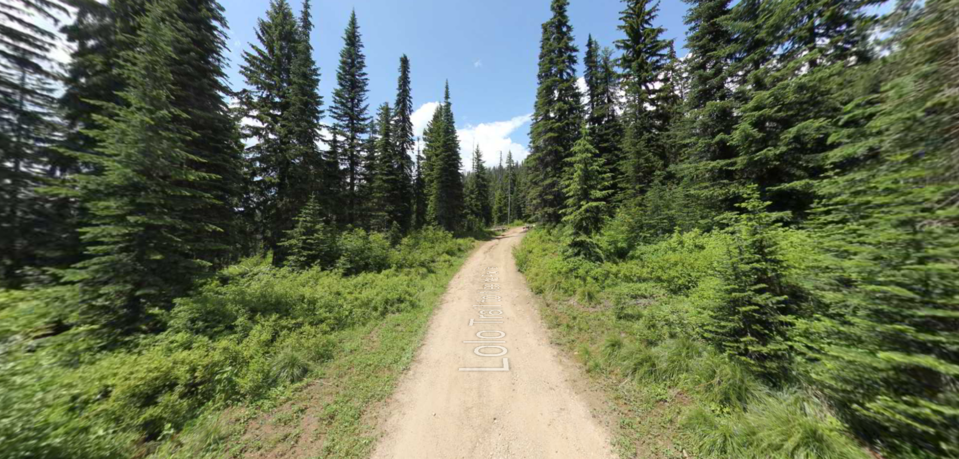
The Lewis and Clark Descent Trail of September 4th, 1805
The September 4th, 1805, Descent Trail is a special destination along the National Lewis and Clark Trail because, hikers who go to that 3-mile cleared Wilderness Trail segment of the 1805 National Lewis and Clark Trail, will walk “in the footsteps of Lewis and Clark”. The reason for that is the unique narrow ridge line of Camp Creek Ridge in southwestern Montana, the Corps Descended that day in 1805. The 3-mile cleared wilderness trail segment of the Corp’s Descent is an easy descending hike with a narrow ridge top with plenty of space for today’s hikers but not much room for 35 people (including the Shoshone Guide Toby and his son and 29+ horses. The geography of the Camp Creek Ridgeline narrows in a few places to only 10 feet wide, so you know at those locations you are “in the footsteps of Lewis and Clark”. Footsteps as in a footprint of 35 people and 29+ horses, since at those locations, the Corps and their horses couldn’t have been anywhere else. Enjoy
This Lewis and Clark Descent Tail can be accessed just off highway 93 in South Ravalli County at mile marker 2.5 to FS Road 729 and 73568, to the upper trail head. The interpretive trail head sign there opens a window into the difficulties that the Corps survived from the day before in ascending to the “Dividing ridge” with their new horse stock obtained in Lemhi, Idaho from Sacajawea’s family, the Shoshones, just days before. For a map of the access to the Descent Trail see page 58 of the book “Lost Pass 1805”. This is a Wilderness Trail so you will follow wilderness trail rules, look for the “blaze” and trail markers at any crossings.
Per Clark’s journals, September 3rd, 1805 was a brutal day which resulted in 7 or 8 of the Corps newly acquired 29+ horses falling in the steep terrain [on the Idaho side of Lost Pass] and becoming injured. The 29+ horses had been determined to be insufficient by the captains to get the Corps to the Pacific and now they had at least 7 less than that. The Corps was in trouble. Then that night near the top of the “Dividing ridge” it snowed, the Corps had little or no food to eat as they lay down to sleep. Their first experience with Rocky Mountain cold, snow and hunger- brutal.
The journal of private Joseph Whitehouse the morning of September 4th, 1805 sums it up: “the morning clear but very cold. Our mockersons froze hard. the mountains covered with snow. 2 mountain sheep Seen by one of the men. we delayed until 8 oClock A.m then set out and ascended a mountain without anything to eat. The snow lay on the mout. So that it kep on our mockisons. the air very cold our fingers aked with cold. we [de]scended the mountain down a rough rocky way [today’s Sacajawea Run at Powder Mountain Ski Area and Camp Creek ridge] and along through a large thicket of balsam fer timber [Whitehouse Thicket and Witness Trees] in which we killed a dozen fessents then descended down [camp Creek ridge] to a large valley [Sula] on a branch [Camp Creek] and halted to dine our hunter killed a Deer. Saw fresh Indian Sign. we eat our deer”. we proceed on down the valley [Sula] we arrived at a large encampment of a large band of the nation [Salish] of about 40 lodges. they have between 4 and 500 well looking horses now feeding in this valley or plain [Sula] in our view.
Witness Trees
Reading the journals of Ordway (a Sargent) and Whitehouse (a Private) on that Descent of the Corps, both noted they “passed through a large thicket of pine and balsam fer timber”, mentioned above. Well, when you hike the Descent Trail in the first half mile you will encounter and pass through that “thicket”, also called out on the Descent Trail Rack Card location “F” as the “Whitehouse thicket.” Many of the trees in this thicket have been core sampled by the Forest Service and found to be over 270 years old and therefore are witness trees, Trees that there when the Corps passed in 1805. Go hug a witness tree. Passing through this large thicket of pine and balsam fer timber will be the highlight of your experience of getting to know about the Lewis and Clark Expedition.
Farewells to the Salish (Part)- from Bruce Mihelish Certified Interpreter
The Corps were then received by the generous Salish people who were about to break camp and head east for their fall buffalo hunt. The natives called this river “Waters of Red Osier Dogwood”. [This chance meeting with the Salish was purely luck or divinely inspired]. Red fall colors were beginning to appear. This valley was “the Big Clear” to these natives and this was a last stop before heading over an ancient road the Expedition missed earlier (Gibbon’s Pass). The Indians would rendezvous with the Shoshone near the Three Forks of the Missouri. There was strength in numbers. These allies were the same friendly people who provided the Corp thirty ponies a few weeks earlier. They were Sacajawea’s people.
The Bitterroot Salish (Selis’) people made a conscious decision to be helpful for the haggard travelers. Chief Three Eagles (Tchliska-e-mee) ordered that “these strange people were not to be mistreated or harmed.” A weak, vulnerable Corps stumbled off Lost Trail Pass that day in tough shape. The Corps had chosen a passage [over the “Dividing ridge”], the Indians avoided. It was too steep and rough. The new visitors were cold and hungry. Seven pack ponies were lame and could go no further. They had fewer ponies than needed to continue. The Shoshone had provided 29 to the Corps. Sacajawea rode her own privately owned pony provided by her Shoshone people. It was necessary. She was carrying a baby. The mission was in dire straits after their treacherous passage on Lost Trail. Winter was approaching in these unforgiving mountains. The Salish people provided robes for warmth, roots and berries for food, and restocked the pack outfit with seventeen fresh ponies. Three colts were added as emergency food. The herd grew to 43 animals. Ropes and saddles were provided. These gifts all ended up saving lives and the mission. The expedition gave up a few trivial trade items in turn (peace medals, shirts, flags).
So, the Corps went from freezing and hungry to warm and fed and found a helpful Indian Nation [Salish] with which to trade for the additional horses they needed and replace their injured ones. The Descent Trail of September 4th, 1805 was as good to the Corps, as the September 3rd, 1805 climb of the mountain had been bad. Enjoy your September 4th ,1805 Descent hike “in the footsteps of Lewis and Clark”. It is good. The cover of the book “Lost Pass 1805” is a photograph of the Dividing Ridge from where the Corps Descended Camp Creek Ridge at about the halfway point of the three-mile Descent Trail hike.
Sources:
The Journals of Lewis and Clark Expedition Volume 11, The Journals of Joseph Whitehouse May 14, 1804-April 2, 1806, pg 299.
The Definitive Journals of Lewis & Clark, Through the Rockies to the Cascades, Volume 5 of the Nebraska Edition, page 185
The Journals of Lewis and Ordway, Milo Quaife, The State Historical Society of Wisconsin page 280.
The Trail Between the Rivers, Ted Hall, A legacy of the Lewis and Clark Expedition, Stoneydale Press “in the Footsteps” locations page 79
Lost Pass 1805, A closer look at the Lewis and Clark Route of September 3rd, 1805, directions and maps to the Descent Trail page 58.
Farewells to the Salish Friday September 6, 1805, Bruce Mihelish Certified Interpreter.
Descent Trail Rack Card, Bitterroot Heritage Civic Group, Darby Montana.
Distance Unit:
Distance Unit:


A trail starting at Hauser Dam and overlooking the Missouri River.