The Lewis and Clark National Historic Trail is not your average trail. In addition to being a course of travel, it is an important part of early American history. The Lewis and Clark Trail now spans the United States for about 4,900 miles crossing 16 states and 15 tribal lands. It also includes 1,439 miles of water trails and 6,157 miles of auto route. In 1978, Congress officially identified the Lewis and Clark National Historic Trail as one of the historically significant trails in the national trails system (NTS).
Why Did Lewis and Clark Go on Their Expedition?
In 1803 the president of the newly independent United States, Thomas Jefferson, struck a real estate deal that changed the course of history. This was the Louisiana Purchase. The addition of this new land dramatically expanded the size of the United States and mostly remained uncharted. Luckily, Jefferson had been preparing his secretary Meriwether Lewis for westward travel years prior. Meriwether Lewis spent this time studying various subjects in the natural sciences. He had been hand-selected by the president to undertake the task of exploring this new frontier, and when the time came, he was ready.
In a letter to Lewis, Jefferson laid out the directives and guidance for the journey that lay ahead. He stated, “The object of your mission is to explore the Missouri river, & such principal stream of it, as, by it’s course & communication with the waters of the Pacific ocean… may offer the most direct & practicable water communication across this continent, for the purposes of commerce”. The primary goal of the expedition was to find an all-water route to the Pacific Ocean: the northwest passage.
What is the Corps of Discovery?
For the journey, Lewis called upon his friend William Clark to serve as co-captain. Clark replied, “no man lives whith whome I would perfur to undertake Such a Trip,”. Lewis and Clark both had a military background and familiarity with Native Americans, which proved valuable during the expedition. Clark performed most of the surveying while Lewis took charge of the scientific exploits on the trip. As for the rest of the crew, the objective was to find and recruit “some good hunters; stout, healthy, unmarried men, accustomed to the woods, and capable of bearing bodily fatigues to a considerable degree,”. Lewis and Clark assembled a crew of about 40 men and one dog, a Newfoundland named Seaman.
Among the men were professional boatmen, interpreters with Native heritage, French interpreters, a fiddler, soldiers, and an enslaved man named York who was Clark’s “body servant”. They spent the winter of 1803 at Camp River Dubois preparing for the expedition. This is where Lewis, Clark, and their crew became the Corps of Discovery. Toussaint Charbonneau, Sacagawea, George Drouillard, and a slave named York later become permanent members of the Corps for varying lengths of travel.
What Present-Day States Did Lewis and Clark Travel Through?
Meriwether Lewis and William Clark’s Corps of Discovery traveled through a total of 16 modern-day states — starting in Pennsylvania and making its way to the Pacific coast in Washington and Oregon. The Lewis and Clark National Historic Trail (LCNHT) expanded eastward to Pittsburgh in 2019, adding the states of Indiana, Kentucky, Ohio, West Virginia, and Pennsylvania along the way.
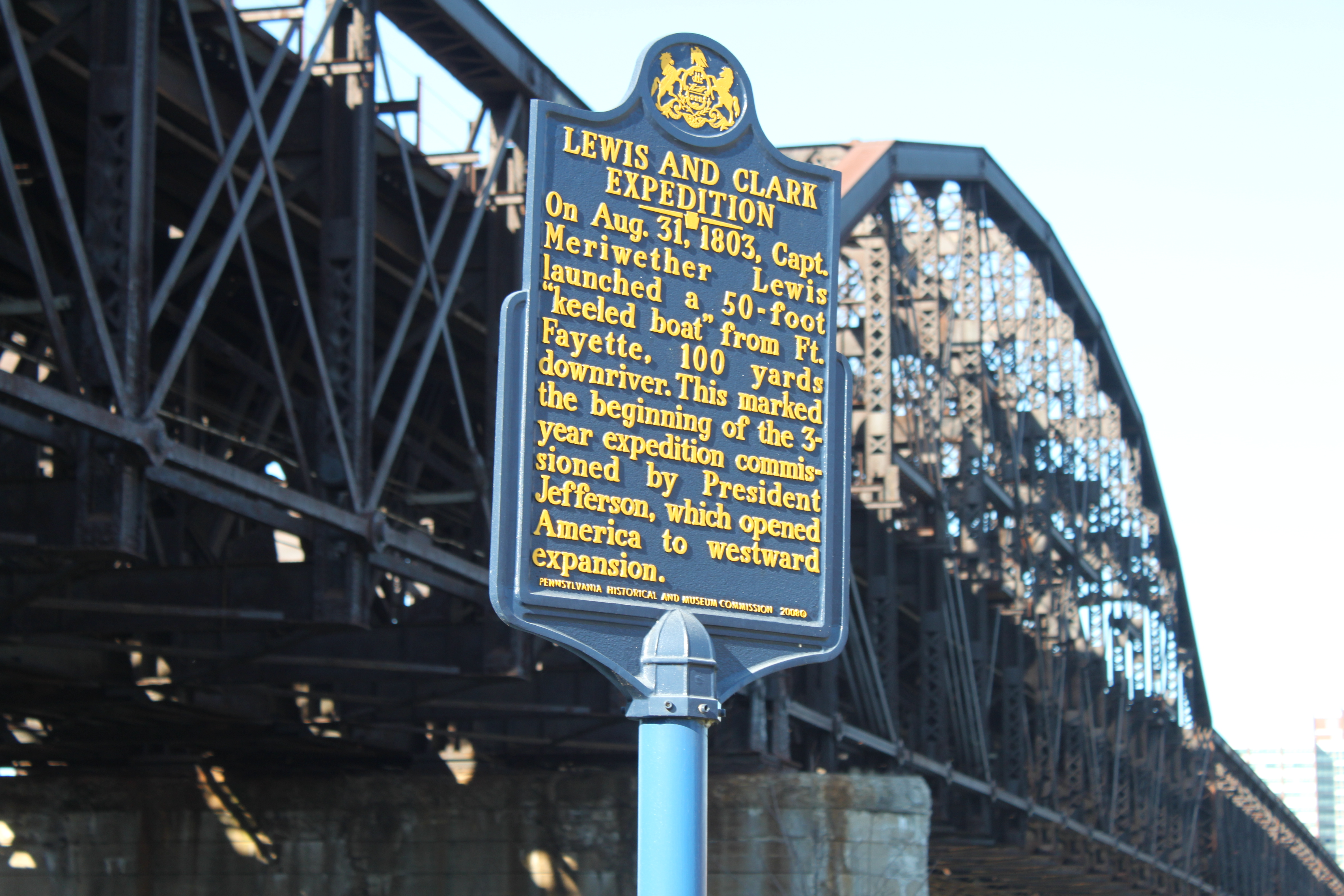
1. Pennsylvania
Where did Lewis and Clark start their expedition? Well, you’ll find your answer in the Keystone State of Pennsylvania. Pittsburgh is where the Corps’ iconic keelboat was first launched and is now officially recognized as the starting point of the journey by the LCNHT. You can visit the historic launch point across the street from the Senator John Heinz History Center.
2. West Virginia/Ohio
From Pittsburgh, the trail then continues west along the Ohio River, which serves as the border of present-day West Virginia and Ohio. Lewis arrived in Wheeling, West Virginia in September 1803, which he described at that time as a “considerable village.”
While Portsmouth, Ohio, may not have even been officially founded by the time Lewis got there, he did traverse the area in 1803 shortly after noting his visit to Wheeling.
3. Kentucky/Indiana
Lewis continued westward with the keelboat past the states of Kentucky and Indiana, which are also separated by the Ohio River. The Falls of the Ohio near Louisville, Kentucky, was where Lewis met up with Clark, Keelboat and supplies from Pittsburgh in tow.
4. Illinois/Missouri
The Corps’ time on the Mississippi was spent sandwiched between the states of Illinois and Missouri, where it sailed north to St. Louis, Missouri. Gateway Arch National Park is also home to the Museum of Westward Expansion, which hosts extensive artifacts from Lewis and Clark’s journey.
5. Kansas
Kaw Point in Kansas City, Kansas, hosted Lewis and Clark for a period of rest and recovery in June 1804. The historic point, seated at the confluence of the Missouri and Kansas Rivers, is home today to a 10-acre park.
6. Nebraska/Iowa
The northern section of the Missouri River creates a border between modern-day Nebraska and Iowa, both of which were visited by the Corps of Discovery. Lewis and Clark visited a site called Omaha Big Village, which is located near present-day Homer, Nebraska. But, the crew didn’t get to see the village at its heyday of power and fur trade, as a large chunk of its population, including leader Chief Blackbird, was wiped out by a Smallpox outbreak in 1800 — four years before the Corps of Discovery made its way over.
7. The Dakotas
North Dakota and South Dakota are a significant part of the Lewis and Clark Expedition, because it is where the crew first made contact with Sacagawea. She was living among the Mandan and Hidatsa tribes near present-day Bismarck, North Dakota, when she first made contact with the Corps of Discovery. She was the only woman who traveled with the crew and played a significant role in navigation.
8. Montana
Montana is home to Beaverhead Rock, which is another important landmark to Lewis and Clark’s expedition. It was here where Sacagawea recognized the location of her former home, which was settled by her Shoshone relatives. This helped the Corps of Discovery acquire new horses for their upcoming and mountainous westward Pacific journey.

9. Idaho
Lewis and Clark spent lots of time in present-day northern Idaho among the Nez Perce Tribe. The Nez Perce Indian Reservation is still protected today and encompasses about 750,000 acres of land. The Corps of Discovery crossed from present-day Montana into present-day Idaho through Lolo Pass in the northern Rocky Mountains.
10. Washington/Oregon
Lewis and Clark’s final western push was done along the border of what are now the states of Washington and Oregon. The end of the journey is commemorated with a statue in Seaside, Oregon, which was reached in 1805. The Corps also reached the Pacific at Cape Disappointment near present-day Long Beach, Washington, where they spent a winter.
Which Rivers Did Lewis and Clark Travel Along?
What river did Lewis and Clark follow on their outbound expedition to the Pacific coast? Well, the Corps of Discovery set sail on a multitude of bodies of water, including the Ohio, Mississippi, Missouri, and Columbia Rivers. With the LCNHT’s 2019 eastward expansion, you can now say the journey started all the way out east of the Ohio River in Pittsburgh.
1. Ohio River
The Corps of Discovery traveled all 981 miles of the Ohio River. The river starts at the confluence of the Allegheny and Monongahela Rivers in Pittsburgh, Pennsylvania, and flows southwest all the way to Cairo, Illinois, where it meets the Mississippi.
2. Mississippi River
Lewis and Clark spent only a short distance on the Mississippi River. The crew took it north from the Ohio River, just to where the Missouri River begins near St. Louis — around 150 miles.
3. Missouri River
The Missouri River is the longest in the United States, and Lewis and Clark traversed all 2,341 miles of it. The Corps of Discovery followed the river northwest from St. Louis all the way to where it begins at its headwaters near Three Forks, Montana in the Rocky Mountains. From here, the river splits into the Jefferson, Madison, and Gallatin Rivers, which were all named by Lewis and Clark themselves.
4. Jefferson River
The westernmost split of the Missouri River was deemed the Jefferson River, which Lewis and Clark further followed southwest, which was against the current. They took this river toward Camp Fortunate before trudging on to the Continental Divide at Lemhi Pass.
6. Clearwater River
The Corps of Discovery hopped on the water at Clearwater River, which is located in the Nez Perce area. Lewis and Clark took this river west out of what is present-day Idaho
6. Snake River
Snake River is the largest affluent of the Columbia River, but Lewis and Clark only traveled on it westward for a few miles to link the Columbia River. This ended up being a segment from Clarkstown, Washington, to the confluence of the two rivers near Kennewick, Washington.
7. Columbia River
The Columbia River is a massive 1,243-mile body of water that flows into the United States from Canada, but Lewis and Clark only traversed it for a small segment. The Corps of Discovery hopped on these waters from the Snake River near Kennewick, Washington, and took it all the way home to the Pacific Ocean.

Where is the Lewis and Clark Trail?
The Lewis and Clark National Historic Trail isn’t just in one place, it is a pathway connecting a collection of different cultures, geographies, and historical landmarks across the United States. Today, the LCNHT is more than 4,900 miles long and encompasses 16 states and 15 Indian reservations stretching from Pittsburgh, Pennsylvania, to the Pacific Ocean in Astoria, Oregon.
The easternmost 1,200 miles of the trail were added in 2019 to commemorate Lewis and Clark’s keelboat’s original journey from Pittsburgh to Wood River, Illinois, which is considered a section of preparation for the journey.
Why Was the Lewis and Clark Trail Established?
The Lewis and Clark National Historic Trail was established in 1978 by the National Park Service. The trail itself does not own any land, but it acts as an overarching body of protection and tourism for the various sites along its path. Plenty of different local, federal, and private agencies operate along the trail.
The purpose of the LCNHT is to commemorate the 1803 to 1806 Lewis and Clark Expedition through the identification, protection, interpretation, public use and enjoyment, and preservation of historic, cultural, and natural resources associated with the expedition and its place in United States and tribal history.

Did Lewis and Clark find the northwest passage?
Though the northwest passage was never found, the expedition would reveal so much more. The letter from President Thomas Jefferson also stated that observations of all kinds should be carefully annotated throughout, including those of the natives that inhabited the areas they were sure to cross.
This aspect of the mission was one of intel and diplomacy to be performed in the utmost “friendly & conciliatory manner,”. To assist with this effort, many items were brought for bartering and as gifts for future meetings with the country’s fellow inhabitants. The crew, also called the Corps of Discovery, dutifully carried out these instructions. Because of their diligent journaling, many details of this incredible journey are known today.
How Can I Visit the Lewis and Clark Trail?
You can visit the Lewis and Clark trail by checking out LewisandClark.travel and identifying shops, businesses, parks, and recreational activities along the trail that are most appealing to you.
