Fort Osage
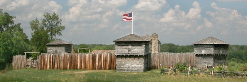
Fort Osage, one of the first military outposts of the Louisiana Territory, was established by Clark in 1808. The Corps of Discovery first passed through the area on June 23, 1804, although no mention regarding the site’s suitability for a fort was noted in the journals. At the time, Clark only documented an island that was then across the river from the later site of Fort Osage. However, when he returned in 1808 as a brigadier general in the Louisiana Territory militia and U.S. agent for Indian Affairs, Clark referenced his initial undocumented impression of the location, writing that he “examined the Situation and the points of a Small Island which is opposit, found the River could be completely defended and Situation elegant, this Situation I had examined in the year 1804 and was delighted with it and am equally so now, […] and fixed on the spot for the fort and other buildings.” In 1810, as Nicholas Biddle prepared the expedition journals for publication, he interviewed and corresponded with Clark in order to elaborate on details within the text. Based on information provided by Clark at this time, the first edition of the journals, published in 1814, revised the original June 23, 1804 journal entry to insert the text: “Directly opposite on the south, is a high commanding position, more than seventy feet above high-water mark, and overlooking the river, which is here but of little width; this spot has many advantages for a fort, and trading house with the Indians.” Following abandonment in 1827, archeologists rediscovered the fort’s foundations in the 1940s. It was then reconstructed to portray the circa-1812 appearance.
Distance Unit:
Distance Unit:


A boat ramp that allows visitors to access the Trail of Tears

Explore the Trail of Tears State Park to delve into a somber chapter in American history. Here, nine Cherokee Indian groups crossed the harsh winter Mississippi River in 1838-1839 during their forced relocation to Oklahoma.…


